Touring Kauai's Crown Jewels
with The Makai Guy
Maintained by Doug Wilson,
MakaiGuy@iName.com
Last text update: 29 January 2009.
Several links updated 26 July 2012
Unless otherwise noted, text and images © Copyright F.D.Wilson,
all rights reserved.
Visit the Makai Guy's
MAILBAG.
Mailbag updated 8 Sept 2001.
|

|
The lush green mountains, plains, and valleys of Kaua`i have
earned it the nickname The Garden Isle. Nurtured by the
tradewinds, the North Shore receives more rainfall than the rest
of the island and tends to be the lushest of the lush, and the
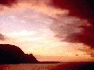
greenest of the green. From stirring mountain views to placid
streams, from majestic bays to towering Pali (cliffs), from
pocket beaches to arching rainbows, the North Shore is a delight
to the eye and a feast for the soul.
As I'm sure you can tell already, this magical place has
established an abiding hold on me. Allow me to share some of
this special spell with you, as we tour The North Shore.
BEFORE WE GET STARTED ...

| As we explore The North Shore, we'll encounter several SIDE TRIPS,
indicated by the signpost you see here. To take one of these trips,
just click on the signpost, and the side trip will open in its own
separate window for your convenience. You can continue your tour in THIS
window while your sidetrip downloads. When you have completed the side trip,
just close its window, or click on the "Close Window" sign you'll see there.
|
You'll also encounter some embedded hypertext links to external websites.
These will also open in separate windows for your convenience.
[NOTE: If you have a "pop-up stopper" utility installed on your system, it
MAY prevent these links from operating. If so, see your utility's
documentation for instructions on how to permit opening additional windows
from this website, or to temporarily disable the utility.]
Here are a couple of quick side trips, to help you with
some of the burning questions that are probably
consuming you already!
The NORTH SHORE
This adaptation of a remarkable Lansat satellite image
illustrates a fact about Kaua`i that applies to the rest of the
Islands as well. Their interiors tend to be rugged, mountainous,
and inaccessible. Most of the roads and development are found
makai (by or toward the sea), with few roads penetrating
mauka (in or toward the mountains).
As you can see, the transition from mountain to
sea tends to be most abrupt on the north to northwest
part of the island, and much of the coastline in this area
consists of basaltic bluffs or outright cliffs. At Na Pali,
in fact, the mountains run right up to the shoreline, leaving
no room for roads, so one cannot drive all the way around Kaua`i.
The stretch of shoreline beginning with Na Pali and ending
with Kilauea Point at the "top" of the island is considered the
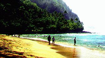
"North Shore". Don't worry, it's not ALL cliffs and bluffs.
The North Shore does have beaches, and some delightful ones at that,
but they tend to collect at the heads of inlets and at pockets
at the base of the cliffs.
Even if you've never been to Kaua`i physically, most likely you
HAVE been there visually -- the scenery is so entrancing that
many film makers have used The North Shore as a backdrop.
George Lucas filmed the opening portions of Raiders of the
Lost Ark here and under Steven Spielberg Kaua`i
became Jurassic Park. Nearly ALL of South
Pacific was filmed on the North Shore, and even Dino de
Laurentis' remake of King Kong found its way here, just
to name a few. In fact, there is an enterprise called Hawaii Movie
Tours making a business of touring Kaua'i
movie locations. We toured with them on our last visit and
really enjoyed the tour..
So who cares whether this is your first visit, or if you're a Kaua`i
veteran? Let's go see the sights!
Tour of the North Shore
Many of the images which follow have been reduced in
size to cut down on transfer time. To see larger versions, you
may click on them individually. These images will load in separate
windows, allowing you to continue reading while they load.
![[Kilauea light house]](kilausm.jpg)
|
|
Kilauea Light House
|
Kilauea Point juts out 200 feet above the sea, forming the
northernmost point on Kaua`i. The lighthouse here dates to
1913, and is on the National Register of Historic Places. The
lighthouse and its grounds make up a small part of the
Hawaiian Island National Wildlife Refuge. The Refuge
extends 1200 miles or so to the northwest and covers hundreds of
small uninhabited islands which make up the balance of the
Hawaiian chain. Here at Kilauea the visitor may see albatross,
frigate birds, shearwaters, white- and red-tailed tropicbirds,
and literally thousands of red footed boobies. (Yes, boobies!
Could I make this up?). Be sure to put Kilauea Lighthouse on
your "must see" list, as the views from the point are
spectacular. Unfortunately, I've been informed by the Kilauea Point
National Wildlife Refuge that the Crater Hill Hike that they used
to provide has been suspended indefinitely. See the side trip
below for what you formerly could see if you were willing to
climb a bit.
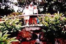
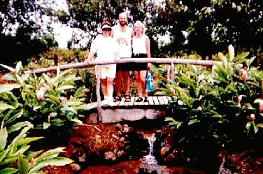
Just outside Kilauea town is the Guava Kai Plantation, a real,
working guava farm. Stop in to their gift shop for a sip or
three of refreshing ice cold guava juice, and load up on
tropical jams, jellies, and syrup as gifts for when you return
home. Our experience says to buy lots, or else you'll use it
all yourself before your friends get their gifts! While there,
be sure to take a few minutes to stroll through their delightful
tropical gardens.

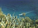
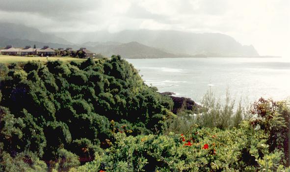
 Heading toward the west, we come to the Princeville Resort.
Situated on a high volcanic bench overlooking the sea,
Princeville is a complete resort community with hotels,
condominiums, shopping, and recreation. The 27-hole Makai golf
course is located here, as is the number one rated course in
Hawai`i, the Prince. You are looking at the intimidating view
from the tee of the Makai Course's signature hole, the par 3
seventh hole on the Ocean nine, across a rocky inlet and toward
the green. We consider Princeville as our Kaua`i "home", as we
have purchased two timeshare weeks at the Makai Club here. You
can visit the Princeville home page, but don't forget to
come back!
Heading toward the west, we come to the Princeville Resort.
Situated on a high volcanic bench overlooking the sea,
Princeville is a complete resort community with hotels,
condominiums, shopping, and recreation. The 27-hole Makai golf
course is located here, as is the number one rated course in
Hawai`i, the Prince. You are looking at the intimidating view
from the tee of the Makai Course's signature hole, the par 3
seventh hole on the Ocean nine, across a rocky inlet and toward
the green. We consider Princeville as our Kaua`i "home", as we
have purchased two timeshare weeks at the Makai Club here. You
can visit the Princeville home page, but don't forget to
come back!
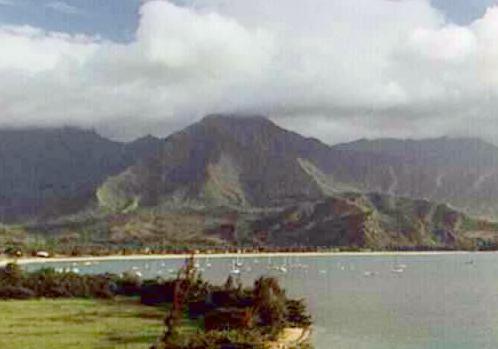
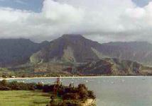 On its west side, Princeville overlooks
beautiful Hanalei Bay, where many of the scenes for South
Pacific were shot. This scenic harbor is the center of
waterbased activities such as sightseeing boat trips (more on
this later) and fishing charters.
On its west side, Princeville overlooks
beautiful Hanalei Bay, where many of the scenes for South
Pacific were shot. This scenic harbor is the center of
waterbased activities such as sightseeing boat trips (more on
this later) and fishing charters.
 The terraces at both the Princeville Hotel and the
Hanalei Bay Resort overlook the bay
and are great places for a sunset dinner, or enjoying a pupu platter,
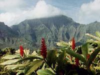
sucking down a couple of mai tais, and watching the sun set beyond Haena Point.
The prominent hump at Haena Point was used as the film location
for "Bali Hai" in South Pacific, and so is almost
universally called Bali Hai today, instead of its rightful name,
Mt. Makana.
The terraces at both the Princeville Hotel and the
Hanalei Bay Resort overlook the bay
and are great places for a sunset dinner, or enjoying a pupu platter,
sucking down a couple of mai tais, and watching the sun set beyond Haena Point.
The prominent hump at Haena Point was used as the film location
for "Bali Hai" in South Pacific, and so is almost
universally called Bali Hai today, instead of its rightful name,
Mt. Makana.
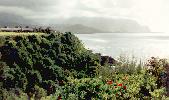
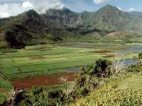 At the head of Hanalei Bay is the broad valley of the Hanalei
River. Across the road from Princeville you'll find a nice
viewpoint for this valley, which serves as a wildlife sanctuary
and is known for its taro production. Taro is grown in flooded
fields, and was a staple of the original Hawai'ian diet. Poi, a
nutritious (if not particularly tasteful to my Midwestern palate) food, is made by
pounding taro roots into paste.
At the head of Hanalei Bay is the broad valley of the Hanalei
River. Across the road from Princeville you'll find a nice
viewpoint for this valley, which serves as a wildlife sanctuary
and is known for its taro production. Taro is grown in flooded
fields, and was a staple of the original Hawai'ian diet. Poi, a
nutritious (if not particularly tasteful to my Midwestern palate) food, is made by
pounding taro roots into paste.
From the overlook, the road switchbacks down to the valley and
follows the Hanalei River into Hanalei town. Our favorite North
Shore restaurant is here - the Hanalei Dolphin, known both for
its open air charm along the river and for outstanding seafood.
When we visited in 1993, less than a year after Hurricane Iniki
had devastated Kaua`i, we were told that the Dolphin was not
going to reopen -- we felt as though we had lost a dear friend.
I'm happy to report the Dolphin is fully restored to its former
splendor and is back in operation. One of our other favorites,
the Shell House, was not as fortunate and is no more. But a
new restaurant has taken its place, Zelo's Beach House.
Another fine dining spot is Auntie Louise Marston's
Tahiti Nui. The guys
will want to check out the achingly lovely painting of a young
polynesian woman which hangs above the bar in the lounge - the claim
is that it is a portrait of Auntie Louise in her youth.
For a less formal meal, there's always Bubba's Burgers, a
Kaua`i favorite from Kapa'a on the eastern shore that has now
added a Hanalei location. After downing your
burger, take a stroll to the back of the small shopping center
where Bubba's is located and peer thru the fence for a lovely
view of Mt. Waialeale.
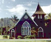
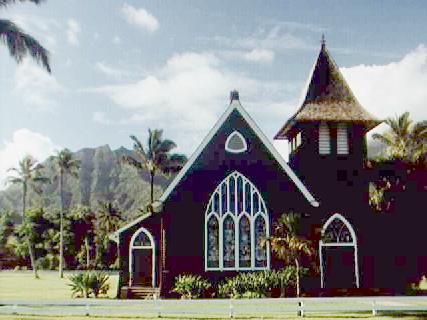
On the west end of town you'll find the old Waioli Hui'iwa
Church, dating from 1912. Some claim its delightful setting make
it the most photographed building in the Hawai`ian Islands.
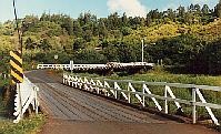 As we continue west, we cross a number of streams which descend
from the mountains to spill into the ocean. These are crossed by a
series of one lane bridges. Aside from adding a quaint touch to the
area, the one-laners have also inhibited development beyond Hanalei, and
that's just the way the residents (and many visitors) like it.
As we continue west, we cross a number of streams which descend
from the mountains to spill into the ocean. These are crossed by a
series of one lane bridges. Aside from adding a quaint touch to the
area, the one-laners have also inhibited development beyond Hanalei, and
that's just the way the residents (and many visitors) like it.
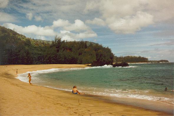
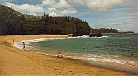 In a short while, you'll come to a place where the road makes a
sharp turn on a bluff overlooking the sea. Typically, a few
cars are parked there (sometimes MORE than a few) for no
readily apparent reason. You can pull over here yourself and follow the
sometimes-slippery trail down to one of Kaua'i`s gems - Lumahai
Beach. Lumahai served as the Nurses' Beach in South Pacific
, the place where Mitzi Gaynor "washed that man right out of
her hair". As enticing as Lumahai appears, caution is advised
if you go into the water, as there is no protective reef here
and the undertow can sometimes be dangerous.
In a short while, you'll come to a place where the road makes a
sharp turn on a bluff overlooking the sea. Typically, a few
cars are parked there (sometimes MORE than a few) for no
readily apparent reason. You can pull over here yourself and follow the
sometimes-slippery trail down to one of Kaua'i`s gems - Lumahai
Beach. Lumahai served as the Nurses' Beach in South Pacific
, the place where Mitzi Gaynor "washed that man right out of
her hair". As enticing as Lumahai appears, caution is advised
if you go into the water, as there is no protective reef here
and the undertow can sometimes be dangerous.
![[Hanalei Colony Resort]](hcolsm.jpg) A little further on we come to Hanalei Colony
Resort, located on one of the few lowlying shoreline areas on this part of
the island. Hanalei Colony is the only seaside resort on the North Shore -
everything else is on bluffs above the ocean. Before acquiring our timeshare in
Princeville, we stayed here several times, and it was always a delight, with the
surf outside our windows gently lulling us off to sleep at night. A nice perk
here was that guests could check out beach mats and snorkel gear for use on the
nearby beaches.
A little further on we come to Hanalei Colony
Resort, located on one of the few lowlying shoreline areas on this part of
the island. Hanalei Colony is the only seaside resort on the North Shore -
everything else is on bluffs above the ocean. Before acquiring our timeshare in
Princeville, we stayed here several times, and it was always a delight, with the
surf outside our windows gently lulling us off to sleep at night. A nice perk
here was that guests could check out beach mats and snorkel gear for use on the
nearby beaches.
Sharing a parking lot with Hanalei Colony is a restaurant that was formerly
Charo's Cantina (yep, THAT Charo of "cuchi cuchi" fame).
Since she moved her entertainment operations to Oahu and sold the place, it went
through a number of unsuccessful incarnations before becoming The Mediterranean Gourmet in 2006.
A little past Hanalei Colony (beyond the YMCA camp) look for a spot with lots of
cars parked along the side of the road. Sometimes it is also marked with an
orange ribbon tied around a tree or telephone pole. Park your car and head back
along the beach access path and you'll come out at one of the real treats on the
North Shore - Tunnels Beach. The name is the result of the arches and holes in
the coral reefs which shelter the beach here. This is one of the premier
snorkeling spots on Kaua`i, as colorful reef fish can be seen by the thousands
feeding on the coral in the clear tropical water.
![[Double Rainbow over Maniniholo Bay]](rainbows.jpg) The scenery above the water at Tunnels isn't so shabby
either. You may recall Matty (Kathleen Turner) in the final
shot of the movie Body Heat, lounging on a beach with
cool drink in hand -- this is the spot. Early one morning a few
years ago I was strolling along Tunnels Beach when an isolated
rain cloud passed overhead, creating a quick but intense squall.
As it moved on down the shore, low-angle sunlight created a
magnificent double anu'enu'e (rainbow) arching over Mt. Makana.
The result is the picture you see here (which also occupies a
place of honor on our living room wall).
The scenery above the water at Tunnels isn't so shabby
either. You may recall Matty (Kathleen Turner) in the final
shot of the movie Body Heat, lounging on a beach with
cool drink in hand -- this is the spot. Early one morning a few
years ago I was strolling along Tunnels Beach when an isolated
rain cloud passed overhead, creating a quick but intense squall.
As it moved on down the shore, low-angle sunlight created a
magnificent double anu'enu'e (rainbow) arching over Mt. Makana.
The result is the picture you see here (which also occupies a
place of honor on our living room wall).
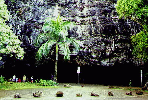
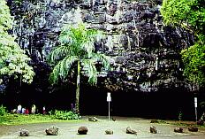 The beach continues around Ha'ena Point and into Maniniholo Bay,
where we find Ha`ena Beach Park. Despite the large swimming
beach, and tranquil sheltered waters of the bay, the most
prominent feature here is probably the large gaping opening
in the rock across the road from the beach. This is the
Maniniholo Dry Cave. The cave formerly was much deeper,
but a tsunami a number of years ago partially filled it
with sand.
The beach continues around Ha'ena Point and into Maniniholo Bay,
where we find Ha`ena Beach Park. Despite the large swimming
beach, and tranquil sheltered waters of the bay, the most
prominent feature here is probably the large gaping opening
in the rock across the road from the beach. This is the
Maniniholo Dry Cave. The cave formerly was much deeper,
but a tsunami a number of years ago partially filled it
with sand.
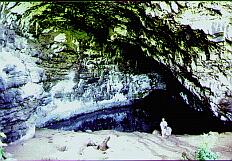
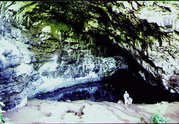
Several other
caves can be found in the area as well, including a couple of water filled "Wet
Caves", Waikanaloa and Waikapalae, which are reached by short
trails. These are all lava tubes, openings left in the rock as lava
flows drained out of their cooling and hardening exterior shells.
Continuing along the Kuhio Highway look for a concrete driveway
on the left marked for National Botanical Gardens at Limahuli
Valley. Pull in here for a refreshing and worthwhile
experience.
A quarter mile or so further on we literally come to the end of
the road, in Ha`ena State Park. High mountains abut the
shoreline here, and the road has nowhere further it can go. The
resulting twenty mile stretch of roadless cliffs is the fabled
Na Pali coast.
There is a small cove at the end of the road, fronted by Ke`e
(kay-ay) Beach. Ke`e is nicely sheltered by a coral reef and is
another well frequented snorkeling spot.
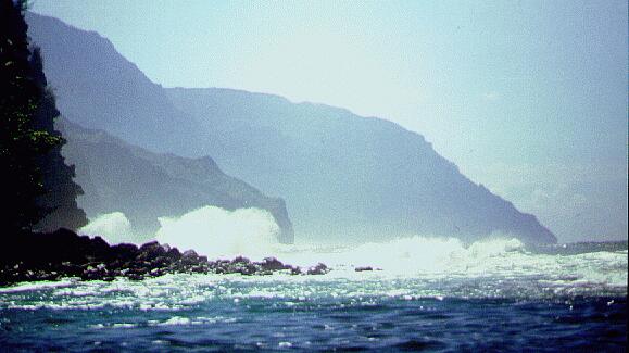
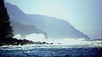 If you walk the beach
to the right and climb out on the rocks a bit, you can get a
glimpse of NaPali, and the surf crashing against the cliffs.
This picture was taken in October, before the BIG winter surf
arrives.
If you walk the beach
to the right and climb out on the rocks a bit, you can get a
glimpse of NaPali, and the surf crashing against the cliffs.
This picture was taken in October, before the BIG winter surf
arrives.
Being the western end
of the road, this is also a popular place to watch the sunset,
in the hope of catching an elusive atmospheric phenomenon called
the "green
flash" just as the sun dips below the horizon. At least
that's the theory -- I've never seen it myself, and have always
wondered if this is a case of the Locals having a good chuckle
at the expense of the tourists.
HIKING NA PALI
The parking lot at the end of the road is also where we find the
trailhead for the Kalalau Trail - an eleven mile trek along
Na Pali which climbs as much as 800 feet above the ocean and is
spoken of with reverence by island hikers.
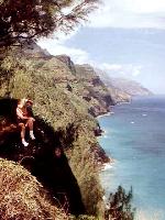 It is not necessary to hike the entire length to enjoy the
trail. If you are physically able, do yourself a huge favor and
take the trail at least the first half mile or so, until it
rounds the headland and presents your first view down the Na
Pali.
If so inclined, you can then turn back, knowing that you have
just experienced the best view of Na Pali that can be found
in the first several miles of the trail. As the old commercial
says, "It just doesn't get any better than this".
It is not necessary to hike the entire length to enjoy the
trail. If you are physically able, do yourself a huge favor and
take the trail at least the first half mile or so, until it
rounds the headland and presents your first view down the Na
Pali.
If so inclined, you can then turn back, knowing that you have
just experienced the best view of Na Pali that can be found
in the first several miles of the trail. As the old commercial
says, "It just doesn't get any better than this".
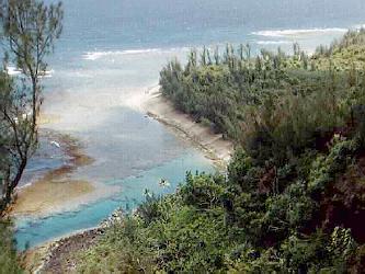
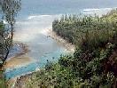 On the way back you'll be treated to a delightful look down
into the cove at Ke'e Beach. From on high we can see the protective
reef and clear water that make this such a nice snorkeling spot.
On the way back you'll be treated to a delightful look down
into the cove at Ke'e Beach. From on high we can see the protective
reef and clear water that make this such a nice snorkeling spot.
But if you decide to keep going, it's only about another mile and a
half to Hanakapiai Beach, a very popular destination. Along the
way, you can peer down into the astonishingly clear water, and
possibly spot sea turtles and dolphins busy turtling and
dolphining.
In former times, during the summer months, you'd have seen another common sight - boatloads
of sightseers viewing Na Pali from a Na Pali boat tour.
Due to a controversial ruling by the
state government in fall of 1998, Na Pali tour operators were banned from operating
from nearby Hanalei, so tour operators were forced to operate from southern ports that were
further from NaPali. These difficulties have now been resolved and tours from Hanalei have been reinstated.
This is still an extremely popular activity on Kaua`i that can provide viewpoints
along Na Pali you can't get any other way, but you probably won't
see as many boats along this part of the
trail as before the ban.
At Hanakapiai Beach you can turn your back on the ocean and hike
two miles mauka (into the mountains, remember?) to the head of
the valley where Hanakapiai Falls tumbles hundreds of feet into a
refreshing crystal pool. The complete roundtrip from the
parking lot to the falls and back is 8 miles. I've found this
makes for a very full day, but you'll have the satisfaction of
knowing you've done something most tourists will never
experience. One word of advice - take lots of drinking water.
The tropical sun can get brutal and many of the streams are
contaminated by wild goats and pigs found in the mountains. You
should not drink from the streams unless you purify them first.
Nope, you can't escape such things, even here in paradise.
For the real adventuresome, the trail ends at the Kalalau Valley,
eleven miles down the coast. To overnight on the trail, you'll
need a permit.
Here's a link to Kurt Bangert and Carola Blasing-Bangert's
description of the same hike to
Hanakapiai Falls.
And here's a link to Kathleen Ann Goonan's account of hiking the
entire trail,
Getting to Kalalau.
Wrapping it up
Well, that's our tour, from Kilauea to Na Pali. I hope you
have enjoyed viewing it as much as I've enjoyed sharing it with
you. If I've managed to pass on just a fraction of the delight
I experience every time I visit the North Shore, the effort to
assemble this site will be time well spent.
If you'd like to let me know what you thought of your visit here, or share
some of your North Shore experiences, I'd be tickled to hear from
you. The easiest way is to use my handy-dandy FEEDBACK FORM.
If your browser doesn't support forms, you can email me at MakaiGuy@iName.com.
If you'd like to see what others have written, you can take a peek
in Makai Guy's Mailbag.
 You might also like to take a peek at
Makai Guy's Links to additional Kauai Information.
You might also like to take a peek at
Makai Guy's Links to additional Kauai Information.
Aloha to you all,
Doug Wilson, the Makai Guy
Return to the NORTH SHORE HOME PAGE where you
can hop a rail to another interesting site on the web.
![[Kilauea light house]](kilaulg.jpg)


![[Double Rainbow over Maniniholo Bay]](rainbow.jpg)