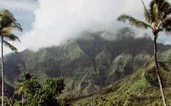
 Mt. Waialeale (wy-ah-lay-ah-lay) is the high volcanic landmass
comprising the center of Kaua`i. It provides a dramatic
backdrop for many of the inland views on the North Shore.
|
The Learning Kingdom's Cool Fact of the Day for 27 Feb 98 Too bad they're no longer in business. Who'd have guessed we'd last longer than they did? |
 Mt. Waialeale (wy-ah-lay-ah-lay) is the high volcanic landmass
comprising the center of Kaua`i. It provides a dramatic
backdrop for many of the inland views on the North Shore.
As tropical tradewinds flow up and over Waialeale's slopes, the air is cooled and the moisture often condenses into a cloud cap over the highlands. With all that moisture, rain is frequent at the top, so much so that Mt. Waialeale is thought to be the wettest spot on earth, receiving well over 400 inches of rain a year.
There is actually a swamp at the top of the mountain, the Alakai, and some of its runoff feeds the prominent waterfall that can be seen tumbling down the upper reaches of the abrupt north face. There are, in fact, streams flowing down through many steep gullies on the cliff face. Most of them are small and hard to see at a distance, but after a heavy rain on the mountain, the number of waterfalls you see leaping off the precipices can be truly astonishing!
![[Picture of Olokele Canyon waterfalls]](cratrwets.gif) Another astounding view is available on a rainy day when many
streams fall down the steep walls of Olokele Canyon, also known
as the "Blue Hole". This area is not readily accessible by road
but is often visited by helicopter tours. Olokele Canyon is
often also referred to as Waialeale Crater, although geologists
are quick to point out that this is just a steeply eroded valley,
not an actual volcanic vent. (Photo courtesy of Air Kauai helicopter tour service.)
Another astounding view is available on a rainy day when many
streams fall down the steep walls of Olokele Canyon, also known
as the "Blue Hole". This area is not readily accessible by road
but is often visited by helicopter tours. Olokele Canyon is
often also referred to as Waialeale Crater, although geologists
are quick to point out that this is just a steeply eroded valley,
not an actual volcanic vent. (Photo courtesy of Air Kauai helicopter tour service.)