
Bow legged tree.
The Rainbow Falls trail starts from the Cherokee Orchard loop above Gatlinburg. Plenty of parking spaces are available, although the lot is usually pretty crowded. The wide path follows the LeConte Creek hollow and is even graveled for a little way. You will find mostly hardwood with a peppering of hemlock, rhododendron, mountain laurel and such. Some of the hemlock and buckeye are of a respectable size, although I found no giants. The roar of mountain creek water is continuously on your ears for the first mile or so. Several spots by the water are cleared to allow easy access to play, picnic, or just sit, relax and enjoy the mountains! Though the way is broad and easy, though the climb is relentless. After about a mile, you slowly diverge upslope to your left. The trail is rocky in places, be careful of slipping! The last two miles wind along a shoulder of Mount LeConte. Vertical climb is 1750 feet in three miles, an average grade of almost 9%. The vertical climb is by U.S. Geologic Survey benchmarks at both ends. The distance depends upon who you believe, but three miles is about right.
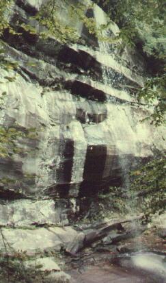
If you persevere, you will hear the unmistakable roar of the falls just before finding a log footbridge across the brook, marking your approach to Rainbow Falls, just upstream. A second identical log bridge crosses the stream to continue upward to Mt. LeConte. The falls offers an uninterrupted plunge of around 75 feet (huge for these parts) with a wide sheer cliff basin surrounding the spillway, forming a large theater with the falls on center stage. Mossy boulders litter the region. Rocks and roots are most always wet and slick. Even if it were permitted, climbing the vertical rock face would be foolhardy.
Continuing onward up the steep path, you will remain solidly in the hardwood forest for a mile or so, as the path now becomes notably more narrow. Vistas will unfold through the greenery now and again. The vegetation begins to very slowly change to the higher altitude heath scrub. (The elevations between the forests below and the balds / scrub above is highly dependent on the location. North faces typically have more coniferous trees and shrubs, whereas the southerly slopes revert to hardwood, though less lofty in height than their kin in the swags. Naturally, many exceptions and variation occur.) Hollow trees are strangely abundant in this area, as is the number of bow-legged trees, those whose roots formed a lens-shaped grasp around fallen logs. When the downed trees rot, the living tree remains suspended in mid-air. (see also Rodney & Priscilla Albright's Walks in the Great Smokies, 1979, p. 99)
Bow legged tree.
It is about four miles (at over 10% grade) from Rainbow Falls to the top of Mount LeConte, elevation around 6500 feet. You will work your way up the wooded ravine cradling LeConte Creek. Winding around Rocky Spur, you can see your goal off to your right. A little further still and the scenery definitely becomes more alpine. The last mile or two somehow seem endless. Rocks become even more numerous along the trail, to the point of completely covering the ground. Further on, the scenery becomes less varied - scrubby blueberry, blackberry (at least by species, I never find any worth eating) and eerie skeletons of Frazer firs supposedly killed by wooly aphids. (It looks as though the top will someday be called LeConte Bald.) The trail traverses grassy, but rocky patches hugging the slopes. At this point, every bend seems as though it must be the last. Good time for a water break. Sit and tell each other (or yourself) that you are almost there! A little further and you will meet up the Alum Cave trail just a quarter of a mile west of the lodge!
Rainbow Falls:
moderate in length, fairly steep, trail is crowded, but extremely well-kept, very pretty forest, but offers few overlooks. It is an ideal stopover for lunch enroute to Mount LeConte.
Mount LeConte:
long hike, pretty steep, well-kept trail, fairly crowded, nice views near the top.