Eastward lies the Ramsey Cascade and Greenbrier Pinnacle trails. A leisurely walk along a well-graded road bed leads to an old parking loop at about one mile. The trail forks to the two locations. Ramsey Cascade is a famous trail of eight miles leading to a spectacular waterfall. Formally, an invigorating rock climb to the top of the falls yielded an extraordinary view westward. However, deaths and injuries on the cliffs have forced the park service to disassemble the bridge over the river leading to the trail to the top. To ban this gorgeous overlook is unfortunate, however the safety of the park visitors is indeed a paramount issue. It is hoped (by me, not officially) that they will open a new safer trail in the near future. Several huge tulip poplars hug the path about midway. The hike is long and tiring, rarely unpopulated, but well worth the effort. In winter, the waterfall is even more beautiful and less crowded. But the trail is sometimes vague under snow, so don't make a first time of it in the winter months. Local ground squirrels will mooch unceasingly in all months. Don't forget your camera (full of film) for this trip.
Alternately, the old parking loop branches to the left up Greenbriar Pinnacle. This trip will tire you even more than Ramsey Cascade. The distance is further and the vertical climb is slightly greater. A stand of sourwood caps the peak. Judging from the topography, I surmise that a view from the defunct fire tower would have rivalled the grandest of views anywhere in the east. Unfortunately, the tower is no more. Only the square concrete scar and wide clearing apologize for the dismantling. No view is to be found here, but rather 'restoration to natural beauty.'
Driving past the Ramsey Cascade turn-off for one half mile, you will find the road gated and ample parking available. This road continues about a mile to the former community of Porters Flat. Several stone fences and a well-built stairway haunt the road - forgotten remnants of a typical Appalachian village. A cemetery lies above the road to the right and should be visited. The road terminates in a loop, offering three paths. The leftmost leads to Charlies Bunyon via backcountry campground #31. The right trail immediately surveys a somewhat restored farmstead of the area typical of the early 1900's. A cantilever barn, spring house and 'house' (actually a hiking club cottage) bring up glimpses of life here in those simple, rugged years. The central trail ascends to Brushy Mountain and Mount LeConte via Trillium Gap.
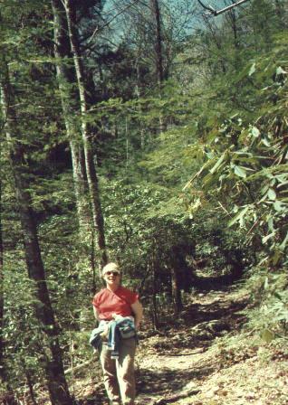
Campsite 31 is published at 3.7 miles one way and elevation gain is about 1500 feet, a respectable day hike with a loaded pack. The trail is well-kept at least as far as the campground. The trail begins as a wide and winding dirt trail. The first half mile can be slightly populated on the weekends, but is generally very serene and relaxing. Continuing on past a two-tree-trunk bridge brings one out of the bottomland at about three quarters of a mile. The trail follows (and precariously overlooks) Porters creek up the hollow towards Charlies Bunyon. The grade is moderate and persistent. A beautiful waterfall on the left is found maybe a mile past the bridge. It is worth admiring, but only worth climbing if you scale the full height, a good hundred feet up. We did not climb past half way, since it looks like the view would be just fair. The forest is lush, mossy, mixed hardwood and relatively free of poison ivy. Several very large trees (poplar and hemlock) bear record that the area has never been clear cut - at least not in recent history. The trail is littered with medium sized rocks: too little to walk on, too small to ignore. Leslie didn't notice them on the way up with hiking boots, but they were a nuisance on the way back with soft soled shoes.
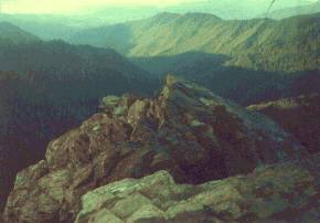
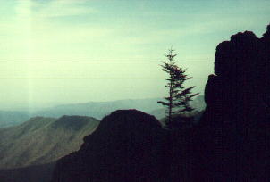
Views from Charlie's Bunyon are outstanding!
Our outing to campground #31 found us off to a late start. We arrived in late twilight, which appeared to be pitch black beneath the dense ceiling of leaves. Swarms of lightning bugs permeated the flat sections of the valley (Albert donned it 'the trail of a million lights' in their honor). They would remain dark for a while, then one or two would blink, and then all at one time hundreds or thousands would simultaneously blink in a wave from one area to another (somewhat like the Big Orange Wave, only quieter). Though enchanting, they tended to disorient the night hiker by constantly taking attention away from the trail. Yet their numbers were unusual even for me, accustomed to myriads of lightning bugs.
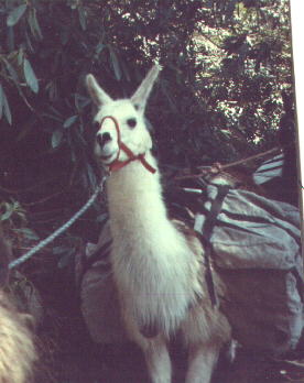
The trail to Trillium Gap is a five and half mile go, add another three and a half to Le Conte. Yet it is quite moderate in steepness. We took this trail to LeConte Lodge in April of 1990. The trail begins with a mile of meandering through rolling hardwood (I never found a split in the trail or the spring shown on the quadrangle map). The long but steady climb up to Trillium Gap is in excellent condition until a few hundred yards shy of the Gap. The trail climbs for three and a half more miles directly up to Mount LeConte. As we were not in the best of shape for this hike (over the winter we sloughed off) we did not opt to go the extra mile to Brushy Mountain . However, if you have not been there, do not neglect to visit as it is one of the finest views in the park. From the gap to Mount LeConte is, of course, well travelled and wide. You may encounter the llama train if you are lucky (this is a thrill to be sure, but watch your step behind them!). The flora changes little during the entire ascent until nearing LeConte. However, swags and northern slopes are notably more coniferous. The upper elevations offer the familiar Frazer Fir and heath scrub terrain (See Mount LeConte). Four and a half easy miles to Trillium Gap, nine miles moderate to Mount LeConte.