Of all the hikes in the Great Smoky Mountains, the one which I have travelled the most often, and the one which has always been by favorite is the Chimney Tops. I am simply thrilled with the variety of sights and activities offered at this stop. True, it is usually crowded, so much so that it is hard to find a parking spot. Call me what you may, this little hike is my top spot.
The first half mile is thick rosebay (white) rhododendron creek bottom. In its season, for a week or two in July, these so fill the hollow that it looks to be freshly covered with a late snow. A smattering of mountain laurel and catauba (purple) rhododendron are pretty in early (maybe second week of) June, but THE time of the year is early - mid July.
Leaving the modestly hilly lowland rhododendron forest of the first mile, the trail splits left and right. A left turn ascends the Indian Gap trail (a sign post is occasionally present). Turn right to tackle the chimneys (this way is not usually marked). Shortly ahead, the fourth wooden bridge crosses the creek (a tributary of the Little Pigeon River) for the last time. Be prepared, just ahead is the 'steep part.' Do not be deceived by any trail books speaking to the contrary, this a strenuous half mile gaining 600 feet over loose rocks. In chilly weather, the earthen embankments on the left often display curious ice formations extruded from frozen ground. A sharp bend to the left followed by a switchback right mark the end of the worst of it. There is still some uphill, but if you have made it this far, don't dare think of turning back now. Ups and downs wind for no more than a half mile to the base of the Chimneys. Several nice views on the right make good resting spots, but no need to use film now as the view from ahead will be similar, but far better.
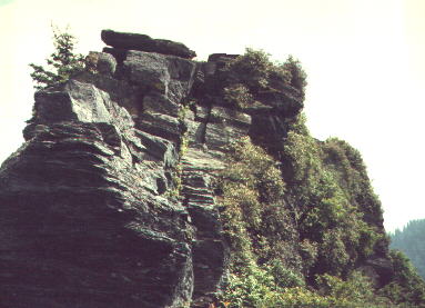
As you approach the ridge, be very careful of the web of tree roots. If your ankles and balance are good, I recommend walking on top of them, but otherwise or if you tend to turned ankles, carefully walk between them. The trail dead ends into what first seems to be a cliff. But upon further inspection, several people are probably climbing up it or have already climbed it. I personally consider it a waste of time to climb this far without ascending the rocks to the top. The view is O.K. from the base, but fabulous from the peak.
Anyone fit enough to make it this far should be able to safely make it up. However, if you are gripped with fear just by the thought of it, better to stay where you are. The route to take up is personal preference and experience. I suggest staying to the left. Some prefer the right, but I have seen unfortunate climbers run into bees in the thicket. Either way, there is no shortcut. The rocks are stable, forgiving, not sharp, and have a multitude of foot and hand holds. I have climbed the Chimneys barefoot, wearing Florsheim Sunday wing tips (no joke) and everything in between. I like tennis shoes, but rock climbing shoes of course, would be optimal (a luxury I have never been able to afford). Go only as fast as you can safely keep holds. The rule is 'don't let go with one hand until you are secure without it,' as people have been hurt here on rare occasion.
Once to the top the view is unforgettable. Walk all the way to the end of the flat section on top for the best view. The gaping holes in the rocks are the bona fide Chimneys. Various myths circulate as to why they are so called. Mount LeConte stretches before you with the Boulevard trail running from there to the right. To the hard left is Sugarland Mountain. The loop appears tiny but is plainly visible in the forest far below. The narrow rocky cat walk ahead is to the lower Chimneys. This is a more challenging climb than the way up and offers no better view, but is not crowded and is great fun for the adventurous. If you proceed, be extremely careful! Rescuers would be few on this jaunt compared to the previous ascent. I have never had a rock crumble here, but don't take that as a guarantee. Lots of fat, juicy blueberries are plentiful in late summer along the way. The upper Chimneys have them, but quickly get chomped by the visitors. If it is rhododendron or blueberry season when you opt to hike the Chimneys, chances are you will see us there!
Chimneys are just over two miles up, strenuous for such a short hike, and time travelled depends on how you negotiate the rocks. I can run up the rock face in a minute or two, some take 30 minutes. The important thing is to go no faster than absolute safety permits. Lower chimneys may take an hour extra. And congratulations! You have chosen what I consider the most enjoyable hike in the Smokies.
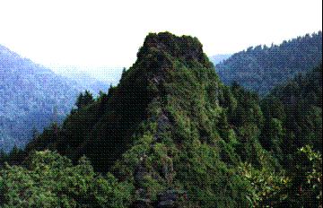
View of the Chimney Tops as seen from the Lower Chimneys